Irvine's rapid transformation from agricultural land to a master-planned city has created a unique geotechnical landscape. The area's alluvial terraces and sedimentary basins, shaped by the Santa Ana River, require detailed subsurface imaging. Seismic tomography in Irvine provides critical data for understanding velocity contrasts and stratigraphy beneath the surface. This non-invasive method helps engineers map soil and rock layers before construction. Before foundation design, many teams combine tomography with a MASW-Vs30 survey to obtain shear wave velocity profiles. The technique also pairs well with electrical resistivity imaging when mapping groundwater or voids in the shallow subsurface.
Refraction tomography resolves low-velocity zones that conventional refraction methods miss, a critical advantage in Irvine's alluvial sequences.
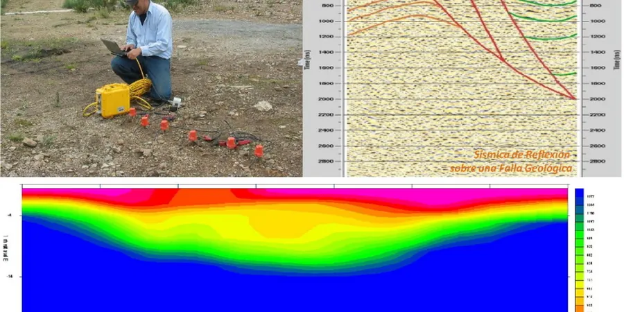
Methodology and scope
- P-wave velocity (Vp) for lithology and saturation
- S-wave velocity (Vs) for stiffness and site class per ASCE 7
- Poisson's ratio for elastic behavior
Local considerations
In Irvine, many times we see projects that skip seismic tomography and rely solely on borehole data. That can miss lateral variability in the shallow subsurface. Older alluvial fans and channel deposits can change stiffness within meters. Without seismic tomography in Irvine, the design team may underestimate liquefaction potential in loose sands or overestimate bearing capacity in cemented layers. Combining refraction with reflection processing helps identify buried channels and paleochannels that pose differential settlement risks. The cost of a few extra survey lines is small compared to the cost of a failed foundation.
Applicable standards
ASTM D5777-18 (Standard Guide for Seismic Refraction Method), ASCE 7-22 (Site Class Determination via Vs30), IBC 2021 (Chapter 16, Section 1613: Seismic Design Categories)
Associated technical services
Refraction Tomography (2D)
Multi-channel surface acquisition with 24–48 geophones, processed using first-arrival picking and SIRT inversion. Ideal for Vs30 mapping, rippability studies, and bedrock depth profiling across large sites.
Reflection Tomography (High-Resolution)
Common-midpoint (CMP) stacking and migration for resolving thin layers, fault offsets, and stratigraphic details. Used in fault hazard assessments and deep foundation planning for Irvine's taller structures.
Typical parameters
Frequently asked questions
What is the difference between refraction and reflection seismic tomography?
Refraction tomography uses first-arrival travel times to create velocity models, best for mapping layer boundaries and Vs30. Reflection tomography processes reflected wave amplitudes, resolving thinner layers and structural details like faults. Both methods are often combined in Irvine for comprehensive subsurface imaging.
How does seismic tomography help with earthquake design in Irvine?
Seismic tomography provides vs30/" data-interlink="1">shear wave velocity (Vs) profiles used to assign Site Class per ASCE 7. In Irvine, where alluvial basins can amplify ground motion, Vs30 values from tomography directly influence seismic design coefficients. This is critical for compliance with IBC Chapter 16.
What is the typical cost range for seismic tomography in Irvine?
For a standard project, the cost range for seismic tomography in Irvine is between US$2,910 and US$5,180. Final pricing depends on line length, number of geophones, and whether both refraction and reflection processing are required.
Can seismic tomography be performed in developed or paved areas?
Yes. The method uses surface geophones and a portable source, so it works on pavement, concrete slabs, and landscaped areas. In Irvine, we often deploy on existing parking lots or road shoulders with minimal disruption. No excavation is needed.